I’ve heard the legends of having to drive to literally everywhere (e.g. drive thru banks), but I have no clue how far apart things are.
I live in suburban London where you can get to a big supermarket in 10 minutes of walking, a train station in 20 minutes and convenience stores are everywhere. You can get anywhere with bus and train in a few hours.
Can someone help a clueless British lemmyposter know how far things are in the US?
EDIT
Here are my walking distances:
- To the nearest convenience store: 250m
- To the nearest chain supermarket: 350m
- To the bus stop: 310m
- To the nearest park: 400m
- To the nearest big supermarket: 1.3km
- To the nearest library: 1.2km
- To the nearest train station: 1km
Straight-line distance to Big Ben: 16km
I’ll just use the same criteria you gave as an example.
- To the nearest convenience store: 1.5mi (2.6km)
- To the nearest chain supermarket: 1.8mi (2.9km)
- To the bus stop: 0.5mi (800m)
- To the nearest park: 0.3mi (480m) - I’m lucky to have several parks in my neighborhood
- To the nearest big supermarket: 2.1mi (3.4km)
- To the nearest library: 2.2mi (3.5km)
- To the nearest train station: 5.1mi (8.2km)
Edit: I live in a mid-size city (300k) on the east coast.
nearly 3km to convenience store or supermarket… in a city? i get the other comments with similar numbers but they said they’re in the middle of nowhere, in the suburbs and such.
also i live in such a big city that 300k feels like a small neighborhood.
I was going to call it a “small” city but Google told me that 300k is mid-size so I went with that ¯\_(ツ)_/¯
The city is ~350 sq km and our tiny downtown area is probably about 1 sq km, so the entire city is kinda like a suburb. Heck, I’m from Houston which is known for its urban sprawl, and yet there’s lower population density where I live now.
deleted by creator
I live in Jersey (New). As a background, I’m at the edge of civilization, I like to joke. If you go west of me, there’s farms, what we call mountains, hiking, all that kinda stuff. To the east of me, it gets more and more urban until you get to NYC.
Here are my walking distances:
- To the nearest convenience store: half a mile
- To the nearest chain supermarket: 1 mile
- To the bus stop: half a mile
- To the nearest park: quarter mile
- To the nearest big supermarket: 1 mile (same as above)
- To the nearest library: I am 1 mile from two different libraries, pretty much smack in the middle.
- To the nearest train station: 1 mile
Adding:
- To the nearest mall: 1 mile
- To the nearest gym: quarter mile
- To the nearest hospital: 1.1 miles
- To the nearest ice cream parlor: .9 miles
- To the nearest record store: .9 miles
- To the nearest arcade: .9 miles
Straight-line distance to Big Ben: Just shy of 3500 miles. Straight-line distance to the Statue of Liberty: 30 miles
Your location sounds pretty optimal.
I live in rural Ohio and I drive about 40 miles (65 km) round trip a day just getting to and from work, and that’s pretty average for a rural area.
The nearest grocery store and back is about a 15 mile (25 km) round trip.
In the rural areas, which account for most of the land area of the US, things are far enough apart that it makes it impossible to survive without a vehicle.
Rural areas accont for most land in europe as well. East of the mississippi the us is overall similear density to europe - less dense but not by much.
I live in the suburbs of a decently sized but not super large city in WI.
- Convenience store: 120 m
- Chain supermarket: 2.6 km
- Bus stop: 5 m
- Park: 450 m
- Big supermarket: 3.1km
- Library: 1.5 km
- Train station: 58.9 km :(
deleted by creator
Here are my walking distances:
- To the nearest convenience store (gas station): 800m
- To the nearest chain supermarket: 1600m
- To the bus stop: 640m
- To the nearest park: 213m
- To the nearest *big* supermarket: 4.3km
- To the nearest library: 2.7km
- To the nearest train station: 1.4km
Straight-line distance to Big Ben: 5890km
deleted by creator
This largely depends on where you are in the US. I have moved a lot over the years, from dense city centers, to the dirt roads of rural America. Here are my experiences:
NYC would probably be the most comparable to your experience in London, but seeing as I haven’t lived there, I can instead talk about Boston. When I lived inside the subway range in Boston (Somerville specifically), my experience matches up with yours. I was ~5 minutes from a supermarket and ~15 minutes from the subway/train stop by foot. I was even closer to a couple bus stops for lines that would take me to places like a mall, nearby universities, or the next subway line over (we don’t have an equivalent of the Circle line).
I currently live in Boston suburbs (Metrowest for people that know the area) and can’t really walk anywhere as my street and adjacent streets don’t have sidewalks. I could try to walk on the street, but with the narrowness combined with the speed at which people drive through this neighborhood, it would not be fun. If I hop in the car, I am ~5 minutes from a strip mall with a supermarket, pharmacy, liquor store, etc. and ~10 minutes from the commuter rail train station that I use to commute to the city for work. If I want to head to a large shopping hub with a mall, then it is ~20 minutes away by car. There is a skeleton of a bus system in my area, but it would require traversing ~1.5 miles on streets without sidewalks to get to the nearest stop for me.
When I lived in a rural area (rural PA), things were very different. To get to the nearest supermarket (a WalMart), it took ~30 minutes worth of driving. If I wanted to go to the mall, it was closer to 60 minutes. I am sure there are even less dense areas than that in this country.
many parts of rural Alaska, for example have grocery stores less than a mile away from most of their population, but require planes to get to anything larger.
Canadian here but this is pretty much the sentiment I wanted to add. If I was answering for the last city I lived in (400k ish, moderate city for here) it would be a very different answer (<30 minute walk generally anywhere in the “metro” area) than for where I live now (rural, 15 minute drive for grocery in three possible directions, pass at least three cannabis dispensaries on the way to any of them and two liquor stores. Public transit is available but is quasi-regional transit too). So grocery is at 15 minutes, and like in your case a mall is an hour, as is a major market like a Walmart, mega grocer thing, Costco…
It is fucked here unless you own property already in the good parts or you are upper class income and can move your ass into the good parts despite the obsene costs.
Oh boy. I used to live in Houston, TX, a city notorious for being car-dependent…
I will present three sets of numbers. First is where I first moved to in Houston, in a supposedly highly coveted, super walkable area home to mostly medical students… Second is the place I lived before I moved out (and I used to boast to people how accessible the place was, by US standards). Third is in Chicago, close to city center (“The Loop”).
And FYI I only lived in places that would be considered to be within the city, so these might be as small as they can get…
- To the nearest convenience store: 900m | 750m | 170m
- To the nearest chain supermarket: 700m(used to be 4.2km) | 450m | 220m
- To the bus stop: 160m(never seen anyone there though) | 350m | 71m
- To the nearest park: 950m | 1.5km | 1.6km
- To the nearest big supermarket: 700m(used to be 4.2km) | 450m | 450m
- To the nearest library: 1.2km | 450m | 1.0km
- To the nearest train station: 7.0km | 3.8km | 2.5km
Fun story about the first location! Everything seems so walkable on paper (close to park, close to highway), until you realize that there was no fucking supermarket anywhere within walking distance… H-E-B only opened a store closeby after I moved there. However, even the super-close grocery store is across the highway and I almost never see any sane people walk there so… For parks I am only counting ones that are good enough to be tourist-worthy, otherwise the latter two locations have pretty easy access to lots of green space
And if you are asking about public transit that are not bus/train: respective distances are 1.4km | 1.0km | 280m. The last number in this series is basically how I chose where to live…
Bank: 24 miles / 38.6km Grocery store: 4 miles / 6.4 km Work: 50 miles / 70km Parents house: 703 miles / 1131 km
I need to move closer for work, but couldn’t afford it do to dumb choices for a bit there.
- To the nearest convenience store: 1.3km (small supermarket)
- To the nearest chain supermarket: 2.25km (Trader Joe’s)
- To the bus stop: 321m (busses 30 minutes apart)
- To the nearest (public) park: 1.1km
- To the nearest big supermarket: 2.89km (Safeway)
- To the nearest library: 1.3km
- To the nearest train station: 1.8km
Straight-line distance to Golden Gate Bridge: 11.6km
My work commute is minimum 40 minutes one way by car. Probably 2.5 hours by bus, with probably 20 minutes of walking, in Texas heat and humidity.
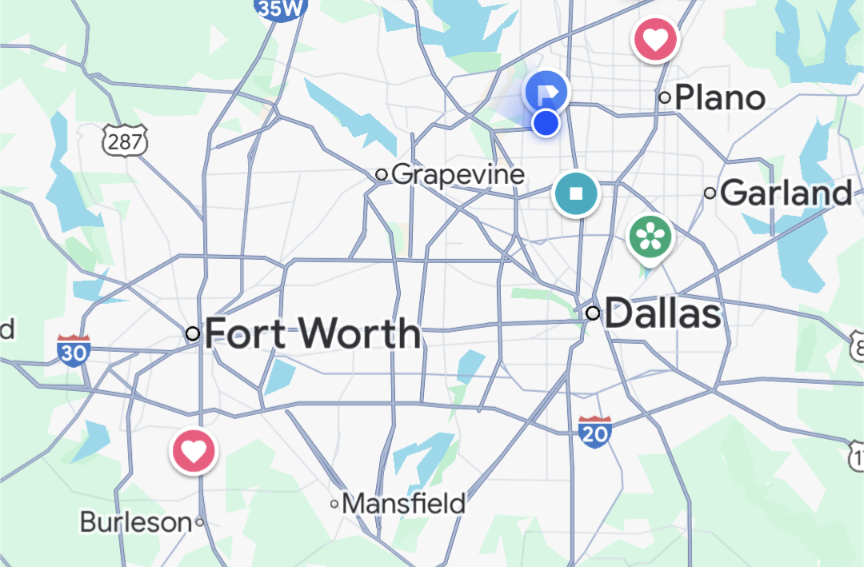
This is a map of the Dallas-Fort Worth (DFW) area in Texas. Yes, we know it looks like a penis. I live near the blue dots at the top right. My husband works near the red heart at the bottom left. That’s about 45 miles and takes an hour most days because both are near highways. Public transit says over 4 hours with three bus/train changes and has a 15 minute walk at each end. Not great when it’s 100F outside.
In many other cities, if you drive 10 miles out of downtown, you can be in the countryside. We can drive 50 miles and be in suburban areas with traffic the entire time. Most people here have a grocery store within 3-4 miles. There are less groceries as you go closer to downtown or in older or cheaper/poorer areas. Convenience stores are closer, but they’re usually gas stations and are pretty expensive for food items. We have several decent restaurants within 5 or 10 miles, but it’s not unusual to drive 20+ miles to go to a favorite restaurant or store or to meet a friend who lives in a different area of town.
In Europe, you can drive for five hours and cross through five cities in three countires. In the US, you can drive five hours and still be in LA.
In the suburbs of a middle-sized city in Ohio, USA. So midwest, but a bit older, higher-density, and more northeastern suburban layout than, say, Iowa. Built up in the 1960s-70s. Almost all single-family suburban homes on large lots.
(these are walking distances, not straight lines)
- To the nearest convenience store: 1.6 km
- To the nearest chain supermarket: 4.2 km
- To the bus stop: 1.5 km
- To the nearest park: 226 meters
- To the nearest big supermarket: 2.1 km
- To the nearest library: 2.6 km
- To the nearest train station: Hahaha! (Ok, it’s actually 78 km, but it’s mostly worthless as a train station)
Straight-line distance to Big Ben: 6297 km
I could easily walk to a grocery store in 10 minutes; however, there’s no sidewalks, no streetlights if it was dark, and I’d have to cross a road with a speed limit of 55mph. On the way I’d pass a gun store, so maybe I could pick one up and pop off a couple rounds into the air to make a temporary crosswalk.